
Clay County, Minnesota
Clay County, Minnesota
Clay County, Minnesota, established in 1862, is located in the northwestern part of Minnesota.
Clay County is bordered:
- on the north by Norman County,
- on the west by North Dakota,
- on the south by Wilkin County and Otter Tail County, and
- on the east by Becker County and Otter Tail County.
Interstate Highway 94, U.S. Highway 10, and Minnesota Highway 34, are the primary east-west transportation routes.
Minnesota Highways 9 and 32, and U.S. Highway 75, are the primary north-south transportation routes.
 Clay County was named after Henry Clay, who was a U.S. Senator from Kentucky, and the U.S. Secretary of State from 1825 to 1829.
Henry Clay also ran for president of the United States on three occasions – in 1824, 1832 and 1844 – losing every time.
Clay County was originally named Breckinridge County, after a man who later became the vice president of the Confederacy.
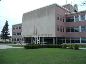
Clay County Courthouse
The current Clay County Courthouse is located at 807 11th Street North, Moorehead, MN 56560.
Clay County Population
Clay County, Minnesota had a population of 58,999 as of the 2010 Census, an increase of 15.2% over the 2000 Census population of 51,229.
Clay County Primary Cities
Moorhead, founded in 1871, is the county seat for Clay County, Minnesota.
The population of Moorhead in 2010 was 38,065.
Other cities located in Clay County, Minnesota include Barnesville, Dilworth, Glyndon, Hawley, Hitterdal and Ulen.
Copyright 2018 – All Rights Reserved
Gary C. Dahle – Attorney at Law
2704 County Road 10
Mounds View, MN 55112
Phone: 763-780-8390 Fax: 763-780-1735 gary@dahlelaw.com
Links:
Western North Dakota Counties – see http://www.dahlelawnorthdakota.com/north-dakota-counties/